Have you ever heard of that sport? Orienteering. Now let's check the wikipedia definition of it. (Don't be mad Dawn, I know how much you hate your students doing their research in Wikipedia).
Orienteering originated in Sweden and is a running sport involving navigation with a map and compass. It involves cross-country, though other forms have evolved. The competition is a timed race in which individual participants use a special purpose map and a magnetic compass to navigate through diverse terrain (most often wooded) and visit, in sequence, control points that are indicated on the map. The course of control points is kept secret from the competitors, until the start, when they are provided with a detailed topographic map on which the course is marked. Competitors start at staggered intervals, are individually timed, and are expected to perform all navigation skills on their own.
For the ones from Tucson who are interested , we even have a Tucson Orienteering Club here. Check out the websitehttp://www.tucsonorienteering.org/
Avez-vous deja entendu parle de la "course d'orientation"?
Bon d'abord voyons ce que wikipedia donne comme definition. La course d’orientation est une activitésportive de navigation avec une carte et boussole qui se déroule en général dans la foret. La forme traditionnelle est une course a pied du type cross-country ; d’autres formes de course d'orientation sont nées au fil des années.
Bon d'abord voyons ce que wikipedia donne comme definition. La course d’orientation est une activitésportive de navigation avec une carte et boussole qui se déroule en général dans la foret. La forme traditionnelle est une course a pied du type cross-country ; d’autres formes de course d'orientation sont nées au fil des années.
THE MAP - LA CARTE
It starts with a special map of a forest. A map that is specifically made for Orienteering.
Ca commence avec une carte tres speciale. Une carte creee juste pour la course d'orientation.

THE COMPASS - LA BOUSSOLE
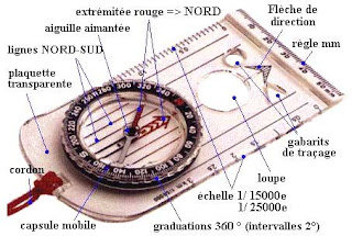
And it can better to have a compass as well, but not any compass. We have those special Orienteering compass.
Et c'est mieux si on a une boussole, mais pas n'importe quel boussole. On a une boussole speciale pour la course d'orientation.
THE CONTROL POINT - LA BALISE
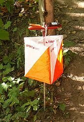
And of course the goal is to navigate in the forest with the map, but we have to make sure we stop at the control points. It is kinda like following an itinerary.
Et bien sur le but est de naviguer dans la foret avec l'aide de la carte, mais il faut prouver que notre itineraire passe par les balises.
THE RUNNING, THE OUTFIT - LA COURSE, LA TENUE


